+7 (812) 328 9282 - Office, +7 (812) 328 9248 - Museum info@karpinskyinstitute.ru
Russian Geological Research Institute (VSEGEI)
In 2018 – 2019, within the scope of the third EMODnet-Geology phase, VSEGEI updated seamless geological maps of the seabed in Russian sectors of the Baltic, White and Barents Seas of (base scales are 1:250,000 and 1:1,000,000). In particular, Quaternary geology maps for Russian sectors of the southeast Baltic and the eastern Gulf of Finland were updated in accordance with new identified Holocene stratigraphic units in the chronostratigraphic scale published by the International Stratigraphic Commission in 2018. The upgrade of EMODnet-Geology-3 semantic dictionaries with the subdivision of the Holocene into three stages was initiated by the Russian group in 2017 and supported by the WP4 (BGR) coordinator. The subdivision of the Holocene into 3 stages: Meghalayan (0-4200 y. BP), Northgrippian (4200-8200 y. BP) and Greenlandian (8200-11700 y. BP) correlates well with evolution stages of the Baltic Sea: the post-Littorina Sea, Littorina Sea, the Ancylus Lake and the Yoldia Sea, and the Quaternary maps of the Russian sectors of the Baltic Sea have become more true-to-life and detailed (Fig. 1).
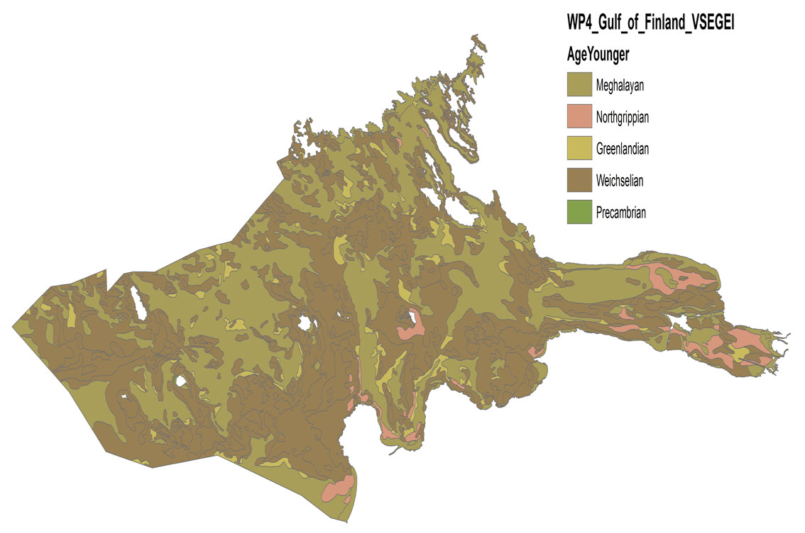
Fig. 1 GIS-layer showing the age of Quaternary sediments in the seabed of the eastern Gulf of Finland
Within the scope of WP4, a new - geomorphological - map was compiled for the Russian sector of the southeastern Baltic Sea, the eastern Gulf of Finland, the White Sea and the southern Barents Sea in accordance with the updated legend distributed by the WP4 coordinator (Fig. 2, 3, 4). Data for the compilation of geomorphological maps were taken from published sets of state geological maps (scale 1:1,000,000), and supplemented by the analysis of bathymetric data and materials obtained during profiling using a side-scan sonar and a multi-beam echo sounder as part of monitoring the state of the subsurface of the onshore-offshore zone of the Baltic, White and Barents Seas and scientific projects carried out by VSEGEI in 2010-2019.
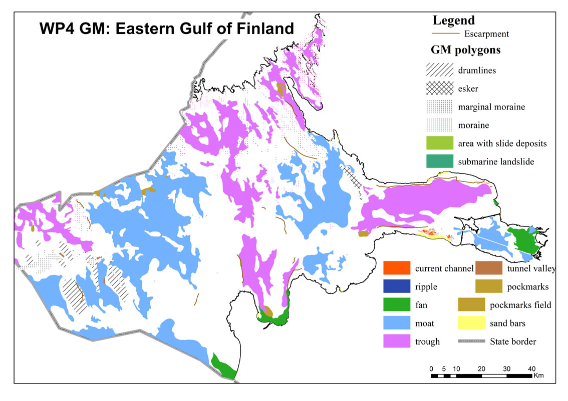
Fig. 2 Geomorphological map of the eastern Gulf of Finland

Fig. 3 Geomorphological map of the Russian sector of the southeastern Baltic Sea
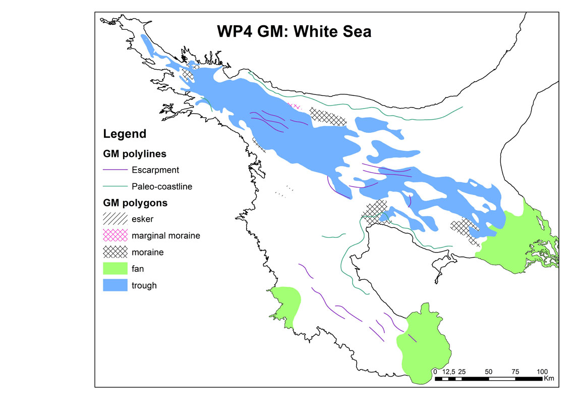
Fig. 4 Geomorphological map of the White Sea
Work was carried out to correlate the geological boundaries in the border areas of the Baltic and Barents Sea, as well as to compare the interpretation of the lithological composition, age and genesis of rocks according to the definitions in semantic dictionaries accepted for use in the EMODnet Geology project.
For the eastern part of the Gulf of Finland and the coast of the Kaliningrad Region, coastal stability maps were developed in accordance with the EMODnet classification (Fig. 5, 6). Information on coastal dynamics was updated using the results of field observations, analysis of remote sensing data and published sources.
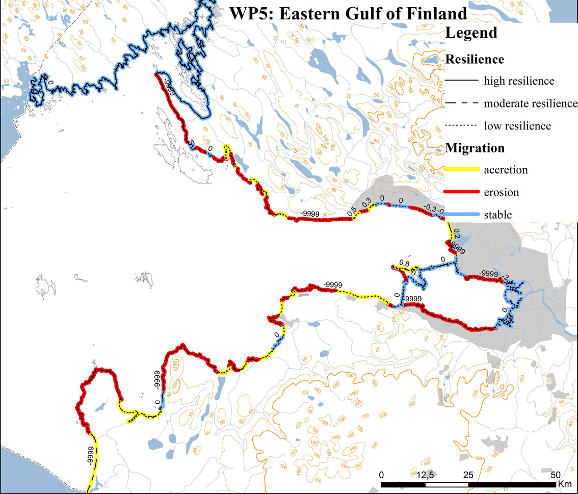
Fig. 5. Map of coast dynamics and stability in the eastern Gulf of Finland
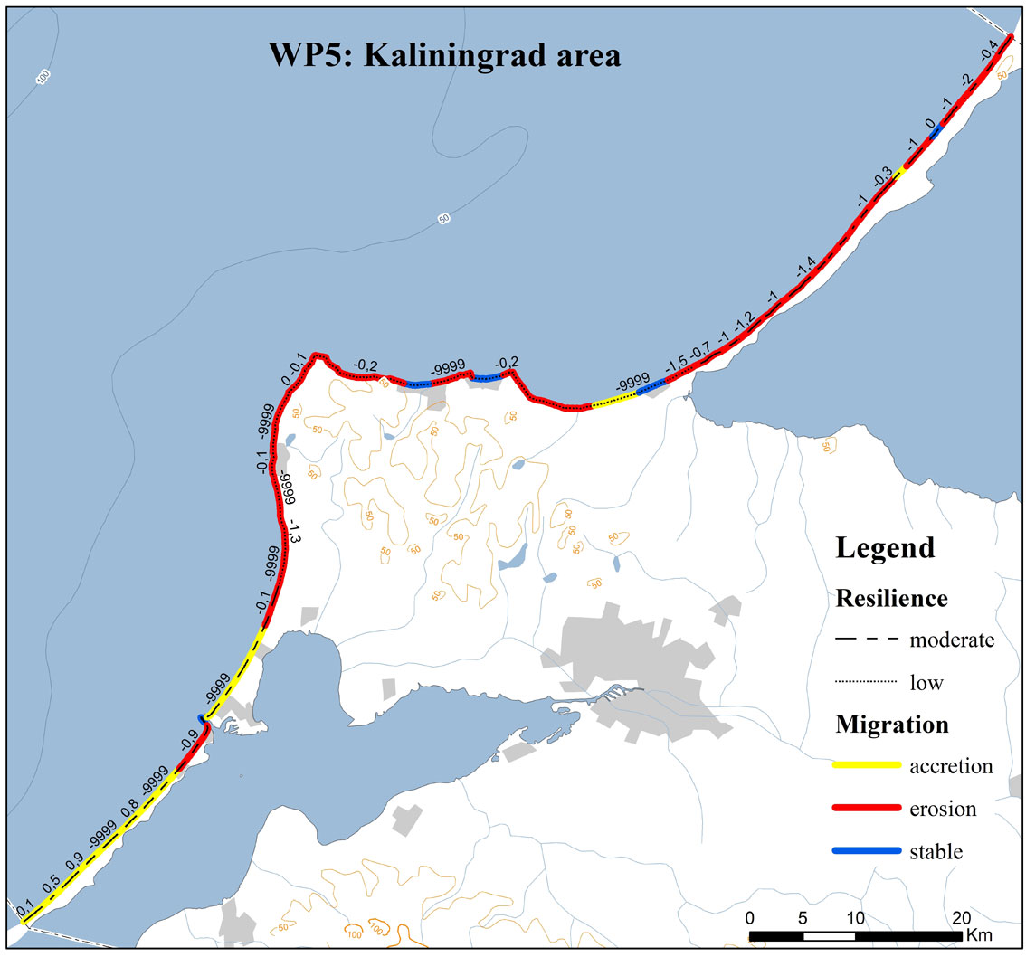
Fig. 6 Map of coast dynamics and stability in the Kaliningrad Region
Maps of geological hazards (events and the possibility of their occurrence) were updated for the eastern Gulf of Finland (Fig. 7). New data were obtained during annual studies of Russian regions of the Baltic Sea, carried out as part of monitoring the onshore-offshore zone and VSEGEI scientific projects (side-scan sonar, seismoacoustic profiling, sampling of bottom sediments, submarine video monitoring), as well as cruises of the R/V “Akademik Strakhov” (multi-beam echo-sounder survey, seismoacoustic profiling, sampling of sediments) conducted by the P.P. Shirshov Institute of Oceanology, RAS, together with VSEGEI. In conformity with WP6 instructions, the map shows pockmarks (gas shows and submarine groundwater discharges) and the position of possible submarine landslides.
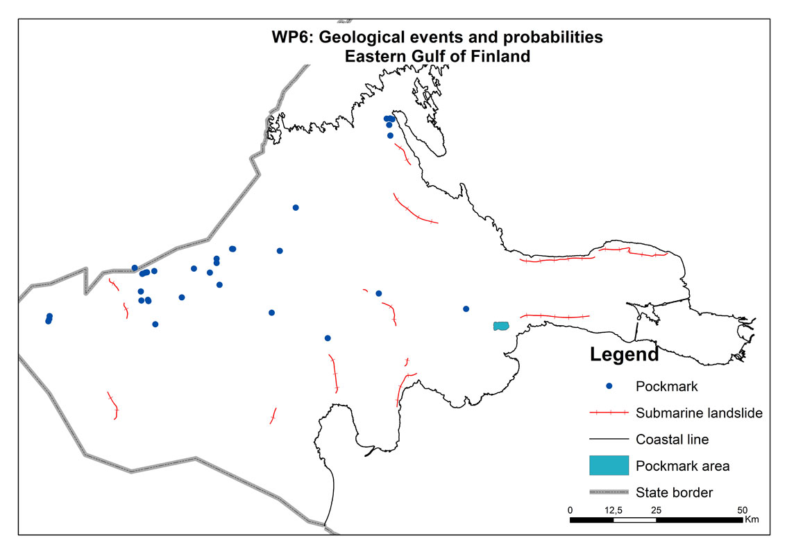
Fig. 7 Updated map of geological hazards in the eastern Gulf of Finland
In conformity with the WP7 work package ideology, the upgraded version of the map of mineral resources shows not only mineral deposits (building materials: sand, gravel), polymetallic (ferromanganese) nodules, hydrocarbons and gas hydrates, but any of their shows mentioned in open published sources (Figs .8, 9)..

Fig. 8 Map of mineral occurrences in the eastern Gulf of Finland
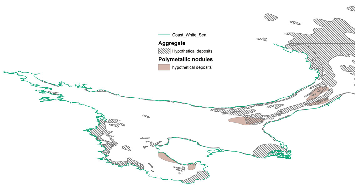
Fig. 9 Updated map of mineral occurrences in the White Sea bottom
Several Quaternary geology maps (Fig. 10) and geological substrate maps (lithological maps) (Fig. 11) were compiled for detailed exploration prospects in the eastern Gulf of Finland based on data obtained by VSEGEI in recent years using profiling by side-scan sonar and multibeam echo-sounder survey, accompanied by sampling of bottom sediments and seismoacoustic profiling.
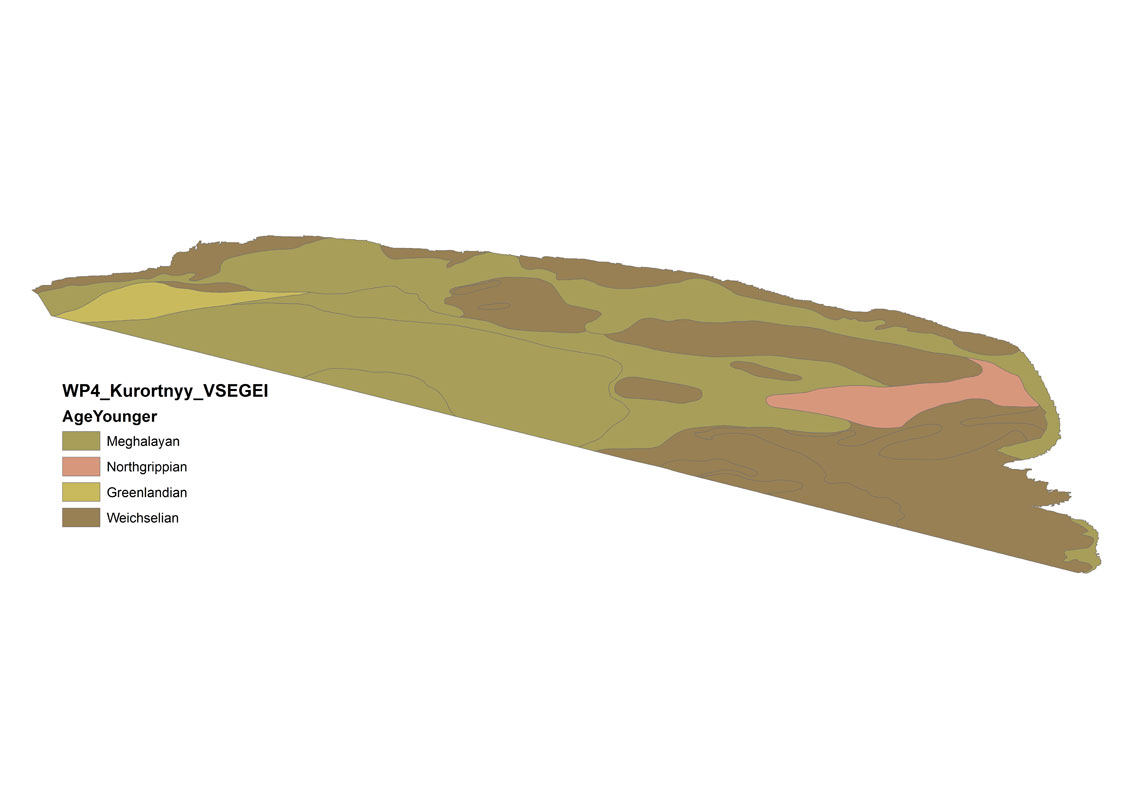
Fig. 10 GIS-layer of the age of Quaternary sediments in the northern coastal zone (Kurortny district, St. Petersburg), the eastern Gulf of Finland
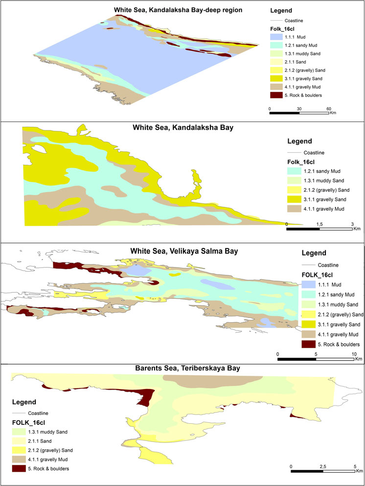
Fig. 11 Maps of the bottom substrate in key areas (Kandalaksha Bay of the White Sea and the southern Barents Sea)
Based on new geological and geophysical data obtained by VSEGEI in the eastern Gulf of Finland, as well as model paleoreconstructions for Russian parts of the Baltic, White and Barents Seas, paleogeographic maps were compiled for a number of time slices that reflect important stages of evolution of these areas during the late Pleistocene and Holocene.
In addition to upgrading the maps, metadata were collected and systematized for bottom sediment sampling stations and seismoacoustic profiles. For this purpose, WMSEG and WFS servers were deployed at VSEGEI and published as corresponding web services. These services can be downloaded and visualized on any portal. Such a technological solution ensures the relevance of the resource - any new downloaded metadata become available to terminal users. During the reporting period, VSEGEI prepared metadata for sediment sampling stations and seismoacoustic profiles for the eastern Gulf of Finland and the southeastern Baltic Sea and for sediment sampling stations in the Russian part of the Barents Sea, which were visualized on the VSEGEI aggregator (Fig. 12).
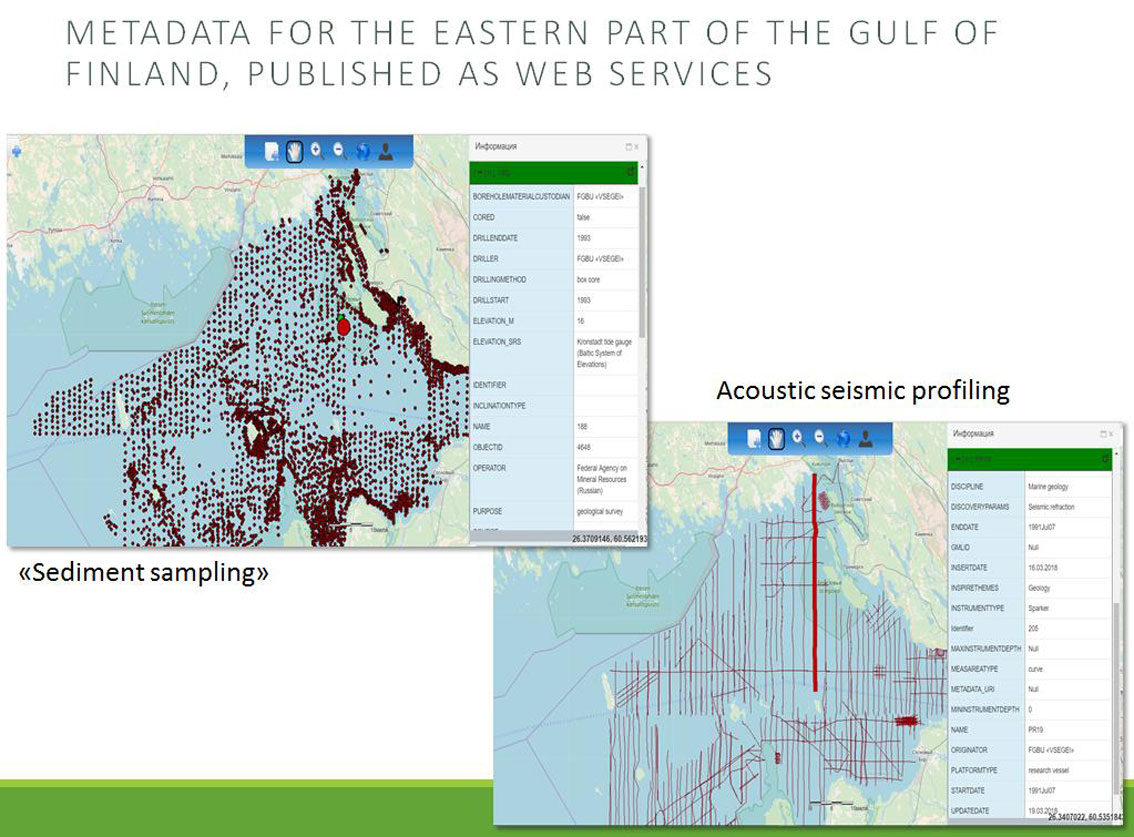
Fig. 12 Sediment sampling stations and seismic-acoustic profiles used in compiling geological maps of the seabed in the eastern Gulf of Finland
Information on the EMODnet-Geology-3 project was distributed in various ways, in particular at international conferences:
The plenary report EMODNET-Geology Project - Creating Harmonized Geological Maps of the European Seas was presented by Henry Wallius together with Russian project participants at the International Scientific Forum “Gulf of Finland - Natural Dynamic and Anthropogenic Impact”, October 18-19, 2018, VSEGEI.
The methodology and results of the EMODnet-Geology project were presented by Tatiana Zubova, VSEGEI Deputy Director General, at the 22nd Intergovernmental Council of the CIS Countries for the Exploration, Use and Protection of Mineral Resources held on November 14-15, 2018. The idea of including the Caspian Sea as a pilot area in the scope of the project in the future was discussed and gained support from the states participating in the meeting.
The poster “EMODnet Geological Project” was presented by Alar Rosentau, Daria Ryabchuk and Olga Kovaleva on April 4-5, 2019 at the workshop “Reconstruction of the Holocene sea level and paleolandscapes” (University of Tartu).
Presentation “New data on the deglaciation of the basin of the eastern Gulf of Finland, the Baltic Sea” (Daria Ryabchuk, Vladimir Zhamoida, Aarno Kotilainen, Alexander Sergeev, Aleksander Krek, Aleksey Amantov, Maria Kapustina, Leonid Budanov, Elena Tkacheva, Outi Hitinen) with reference to the project EMODnet-Geology was accepted as an oral contribution at the 20th INQUA Congress (July 25-30, 2019).
Vladimir Zhamoida presented the EMODnet-Geology project (methodology and results) during the workshop devoted to the possibility of cooperation between the Geological Survey of Iran (GSI) and VSEGEI held on May 6-7, 2018, Tehran, Iran.
Presentation of the EMODnet-Geology results is planned by V.A. Zhamoida and O.A. Kovaleva at the 36th International Geological Congress in India.

