+7 (812) 328 9282 - Office, +7 (812) 328 9248 - Museum info@karpinskyinstitute.ru
Russian Geological Research Institute (VSEGEI)
The Museum of the A.P. Karpinsky Russian Research Geological Institute (VSEGEI) exhibits a unique “Mosaic map of the USSR made of jewelry and precious stones. This map is basically a panel measuring 5,910 x 4,500 metres with an area of 26.6 square metres and weight of 3,500 kilograms. It is made in Florentine and Russian mosaic styles and consists of more than 45,000 plates of 6-mm-thick colour stone glued to slate.
The mosaic accurately reproduces the physical and geographical map of the country. More than 30 varieties of semi-precious and precious stones were used for its production: variegated and monochrome jasper, lapis lazuli, cacholong, orletz (rhodonite), amazonite, precious opal, aquamarine, phenacite, topaz, ruby, rock crystal, emeralds.
The works on the map, which was supposed to be presented at the World Exhibition in Paris, were launched in 1936. One hundred and fifty people were engaged only in mosaic work; in total, 667 people participated in the production of the map and throughout the map production process they worked without any holidays or days off. The work was completed in mid-April 1937.
The World Exhibition held under the motto “Art and Technology in Modern Life” opened in Paris on May 24, 1937. The map entitled “Industry of Socialism” was displayed in the first exhibit hall of the Soviet pavilion, which was dedicated to the Constitution of the USSR and earned many enthusiastic reviews of visitors. The Exhibition Jury awarded the Map as well as the Mukhina’s sculpture “Worker and Kolkhoz Woman” Grand Prix of the exhibition.
This success predetermined the further destiny of the map – it was decided to exhibit it at the World Fair in New York as well. While preparing the map for to the New York exhibition, about 1,000 new symbols of industrial facilities were added and all the inscriptions were translated into English. Moreover, in order to show the route of the polar station “North Pole-1”, the upper part of the map had to be enlarged by 750 mm, which considerably increased the map area. In 1940, the map required a partial alteration of the mosaic set due to new republics joining the USSR and subsequent boundary changes.
In 1946, the Map was transferred to the Hermitage and installed in the Great Throne Room (St. George's Hall) in the Winter Palace. However, during the restoration work, it was decided to restore the map as an administrative map. About 500 names of settlements and their designations in a form of five-pointed gilded stars containing synthetic rubies were added onto the map. The state border of the USSR was changed, boundaries between foreign countries were removed and the contours of the latter were “blurred”.
The Map was installed on the throne podium of St. George’s Hall on April 28, 1948, and had been exhibited at the Hermitage until 1982. In 1982, due to the overhaul of the St. George’s Hall, the Map was dismantled and on April 8, 1988, it was transferred for storage to the VSEGEI Museum. In 2006-2012, new restoration works of the Mosaic Map were carried out and the textolite base was replaced by slate. Moreover, map symbols of industrial enterprises removed during the restoration in 1946 were restored onto the Map. Presently, the map is one of key exhibits at the VSEGEI museum, which never fails to arouse visitors’ interest and enthusiasm.
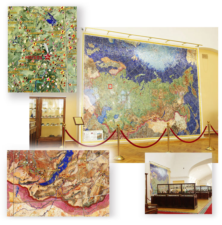
View of the Mosaic Map in the VSEGEI Museum, the view of the museum exposition and fragments of the Map

