+7 (812) 328 9282 - Office, +7 (812) 328 9248 - Museum info@karpinskyinstitute.ru
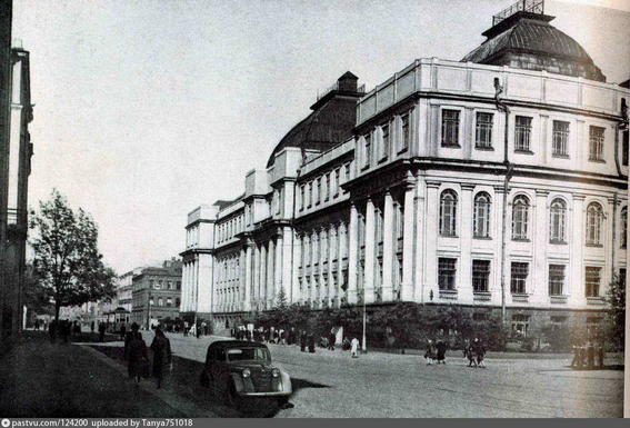
Russian Geological Research Institute (VSEGEI)
1946 – In fulfilment of the tasks set by the fourth five-year plan for the country's geological survey, the USSR Ministry of Geology determined the following main lines of VSEGEI activity:
Generalization of geological materials on the USSR and its regions in order to clarify their geological structure and development as the basis for establishing the formation and distribution regularities of minerals.
Participation in geological surveys at 1: 1,000,000 and 1: 200,000 scale by providing these works with the necessary scientific base, drawing up geological maps for areas that are scientifically and practically important.
Creation of a scientific base for directing prospecting for the main types of minerals in order to provide industry with mineral resources.
Improving the study of the country's geology by conducting special studies on stratigraphy, lithology, palaeogeography, petrology, and tectonics. These tasks were of a long-term nature and for many years determined the work direction of VSEGEI as the head institute of the USSR Ministry of Geology.
1947–1949 – To ensure further progress in the systematic study of geology and minerals of the country, VSEGEI concentrated considerable efforts on the geological survey development. Anticipating the completion of geological exploration of the country at 1: 1,000,000 scale, work was envisaged to create a scientific base for geological mapping at 1: 200,000 scale and, first of all, for major mining regions in the USSR. Both VSEGEI employees and geologists from local geological departments participated in these works. This became a real school of geological surveying, the leaders of which were such experts as N.A. Belyaevsky, V.V. Galitsky, V. D. Golyubyatnikov, L.S. Librovich, S.A. Muzylev, V.P. Nekhoroshev, K.N. Paffengolts, A.I. Semenov, V.M. Sergievsky, P.P. Chuenko and others.
In these years, work began to justify areas for mineral prospecting: molybdenum in the Caucasus (V.G. Grusheva), Altai (N.I. Tikhomirov), in Khakassia (N.M. Uspensky); lead and zinc in South Kazakhstan (I.I. Knyazev, V.P. Nekhoroshev, V.G. Soloviev); iron in the Krasnoyarsk Territory (N.F. Kasatkin, G.I. Kirichenko, Yu.G. Staritsky); mica in the Mama-Chuya district (D.T. Misharev, A.S. Amelanov). A methodology was developed for evaluating ore mineral deposits at various stages of their study and commercial development (N.F. Kasatkin, V.G. Soloviev).
A major achievement of the post-war years was the compilation of two integral maps in VSEGEI: the Geological Map of the European Part of the USSR, the Urals, and the Caucasus at 1: 1,500,000 scale (1948) edited by I.I. Gorsky (Editor-in-chief), L.S. Librovich, B..K. Likharev, A.P. Markovsky, V.P. Rengarten and the Maps of the Quaternary Sediments in the European Part of the USSR and Adjacent Areas at 1: 2 500,000 scale (1950), compiled by S.G. Boch, I.I. Krasnov, V.N. Saks, S.V. Epshtein, S.V. Yakovleva under the leadership of S.A. Yakovlev.
A major event was the publication in 1948 of a three-volume guidebook “Rock Structures” (on igneous, sedimentary, and metamorphic rocks) compiled at VSEGEI under the guidance of Yu.Ir. Polovinkina by a team of authors and which has become for decades a reference book for all petrographers.
")
In 1949, the 13-volume fundamental edition of the Atlases of Guiding Forms of Fossil Fauna of the USSR, begun in 1934 together with the USSR Academy of Sciences, was completed; each of them covered one geological period, and all together were a reliable palaeontological basis for stratigraphic investigations during geological surveys. 10 volumes were edited by VSEGEI employees A.G. Vologdin, I.I. Gorsky, L.D. Kiparisova, G.Ya. Krymgolts, L.S. Librovich, B.K. Likharev, N.N. Luppov, D.V. Nalivkin, A.N. Ryabinin, M.E. Yanishevsky.
1950 – The First All-Union Metallogenic Conference “Ways and Prospects for the Development of Soviet Metallogenic Science” was held, which marked the creation of the VSEGEI metallogenic school, the scientific and methodological foundations of which were laid by S.S. Smirnov and Yu.A. Bilibin, who distinguished three areas of predictive-mineragenic studies: general mineralogy, regional minerageny, special (sectoral) minerageny.
Three-volume monograph “Diatom Analysis” edited by A. N. Krishtofovich and a fundamental guide to pollen analysis edited by I. M. Pokrovskaya, awarded the Stalin Prize, were published. These publications had no analogues in the world at that time.
1953 – Having done a great job analysing the state of affairs in the above-mentioned areas of Russian geology, VSEGEI, being guided by the status of the leading institution, drew the attention of the USSR Ministry of Geology and Mineral Resources Protection (1953) to incorrect tendency to fold up geological surveying and geological mapping in local geological institutions, and also reductions in palaeontological-stratigraphic and other case studies. By the decision of the Ministry, a commission was set up in VSEGEI (E.T. Shatalov, A.P. Markovsky, S.A. Muzylev and others), which reviewed materials on the geological exploration of the country and addressed the Government with relevant proposals.
1954 – May 17, the USSR Council of Ministers adopted a historic decision for Russian geology. It states that one of the main tasks of the Ministry of Geology and Mineral Resources Protection should be considered geological mapping, which is the basis of a comprehensive and systematic geological study of the country, mineral exploration and the establishment of their distribution patterns, as well as the compilation and publication of geological maps.
VSEGEI was entrusted with the scientific and methodological guidance of all the State geological mapping of the USSR, compilation and publication of geological maps, development of guidelines and instructions for geological surveying and compilation of geological maps; creation of stratigraphic charts as a basis for the preparation of map legends; development of standard symbols for the State Geological Maps; research and identification of distribution patterns of mineral deposits in the earth's crust; drawing up forecast maps for new deposits prospecting.
VSEGEI staff was increased by 100 people, new departments (Geological Maps (head S.A. Muzylev), Lithology and Facies Analysis (head A.V. Khabakov), Petrology (head Yu.Ir. Polovinkina) appeared. USSR Ministry of Construction was proposed to build a laboratory building for VSEGEI.
This Decision had a strong influence on the development of geological mapping and increasing the degree of geological and exploratory knowledge in the USSR. The avalanche-like rise in the volume of geological survey, especially at 1:200,000 scale, sharply increased the geological study of the USSR as a whole and of individual regions.
The first Forecast Map for the Diamond Content of the Siberian Platform was compiled at 1:1,500,000 scale (I.I. Krasnov, V.L. Masaitis, M.A. Gnevushev). Geologist from VSEGEI Central Expedition L.A. Popugaeva and collector F.I. Belikov in the area recommended for prospecting by N.N. Sarsadskikh using the pyrope survey method developed by VSEGEI (N.N. Sarsadskikh and A.A. Kukharenko) discovered the first in the Siberian Platform diamond-bearing kimberlite pipe “Zarnitsa”.
Methodological Guide to Geological Surveying and Prospecting (edited by S.A. Muzylev), the handbook for many geological surveyors, as well as the first volume of the Methodological Guide to the Study and Geological Survey of the Quaternary deposits (edited by S.A. Yakovlev) were published.
1955 – Interdepartmental Stratigraphic Committee-ISC (chairman D.V. Nalivkin) began to function under VSEGEI. The Scientific and Editorial Board of VSEGEI was transformed into the organ of the Ministry of Geology and Mineral Resources of the USSR, also functioning under VSEGEI (chairman A.P. Markovsky).
")
The first edition of the Geological Map of the Siberian Platform was published at 1:1,500,000 (ed. T.N. Spizharsky). Instructions compiled by VSEGEI governing geological surveying at 1:1,000,000, 1:200,000, and 1:100,000 scales, compilation and preparation for publication of the State geological maps at scales 1:1,000,000 and 1:200,000 were published. Publication of maps at 1:200,000 scale began. Some instructions compiled by VSEGEI were translated into German, Polish, and Chinese.
Published: a fundamental monograph by Yu.A. Bilibin “Metallogenic Provinces and Metallogenic Eras”, “Geological Dictionary” in two volumes (edited by A.N. Krishtofovich and T.N. Spizharsky), “Methodological Guide for Aeromagnetic Survey” by A.A. Logacheva and others.
This year brought a new major discovery. In the Far East, geologist O.N. Kabakov discovered a large ore cluster with commercial deposits of tin, lead, etc.: Solnechnoe, Ozernoe, Gaychanskoe. For their contribution to the development of the rare metal base of the country, O.N. Kabakov and L.I. Krasny in 1964 were awarded the Lenin Prize.
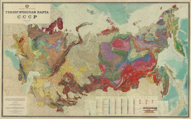
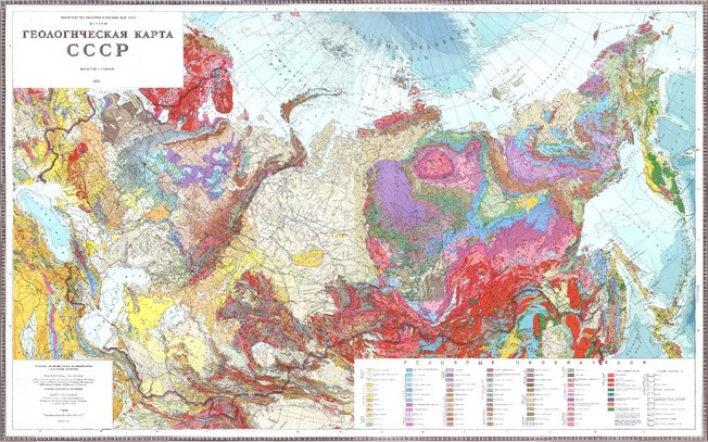
1956 – The second edition of the Geological map of the USSR, scale 1: 2,500,000 (without "white spots") was published under the direction of V.N. Vereshchagin, S. A. Muzylev, and L. P. Kolosova. Editor-in-chief Acad. D.V. Nalivkin was awarded the Lenin Prize, and at the World Exhibition in Brussels, the map was awarded the Grand Prix.
In the second half of the 50s, the introduction of isotope methods (headed by N.I. Polevaya) in VSEGEI work began; K-Are, U-Pb (Pb-Pb) and Rb-Sr methods that are intensively used for radiological age determination of rocks and ore targets were mastered.
1958 – The three-volume monograph “Geological Structure of the USSR” created by the forces of a large team (157 authors) was published (responsible editor A.P. Markovsky, volumes edited by N.K. Ovechkin, Yu.Ir. Polovinkina, L.I. Krasny), accompanied by the Geological Map of the USSR at 1:7,500,000 scale.
Monograph “Geological Structure and Petroleum Prospects of the West Siberian Lowland” was published (edited by N.N. Rostovtsev). In 1964, N.N. Rostovtsev and T.I. Osyko, among other researchers, were awarded the Lenin Prize for participating in the scientific justification of the petroleum potential of the West Siberian Lowland.
VSEGEI began to compile integral geological maps for individual regions of the country at 1:1,500,000 - 1:500,000 scale, which was aimed at assessing the true knowledge of vast regions and creating the basis for planning further work.

